Best Panoramic Alpine Hiking Trails In lombardy Italy
Why Alpine Hiking Trails In Lombardy Italy Are The Best?
From peaceful lakeside walks to thrilling mountain adventures. Whether you’re a seasoned trekker or just love a scenic stroll, there’s a trail here waiting for you. the best panoramic alpine hiking trails in Lombardy, Italy.
Let’s explore some!
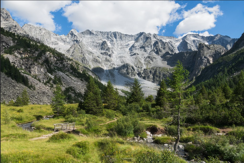
Sentiero del Viandante Trail: lombarby, Italy
Looking for the perfect Lake Como hiking itinerary? This trail has you covered.
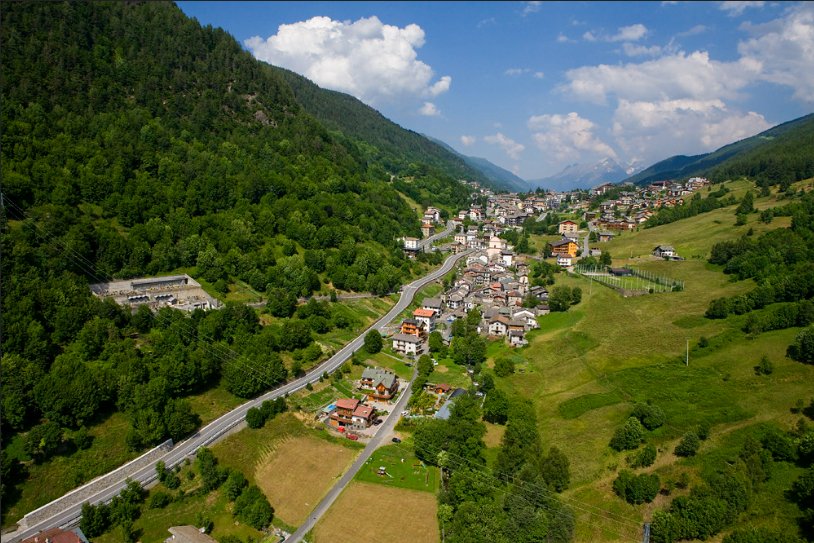
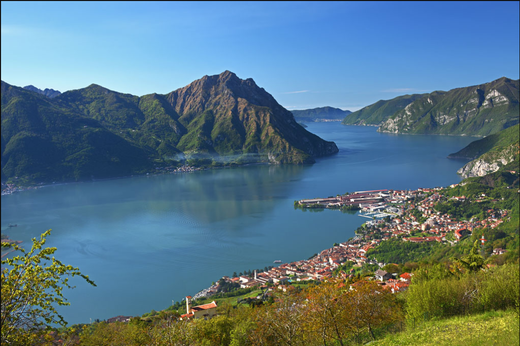
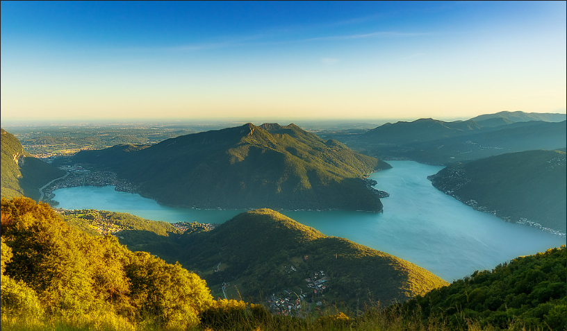
From Lecco to Morbegno trail called Sentiero del Viandante, an ancient route winding along the stunning eastern shore of Lake Como. This 70-kilometer trail, once used by monks, merchants, and wanderers, now invites you to explore its secrets.
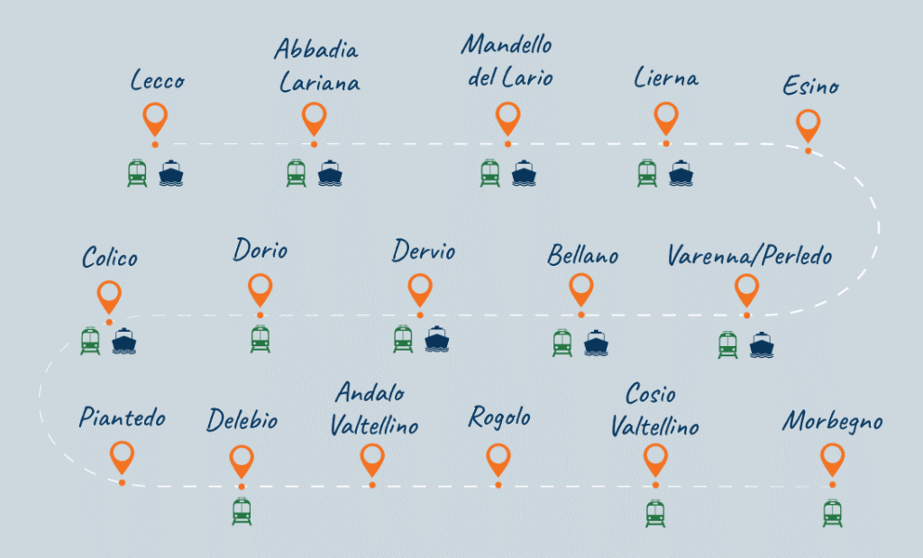
Route and Stages
The trail typically runs from Lecco to Morbegno, but it’s easy to break it down into shorter hikes. With convenient train access along the way, you can start or end wherever you like. Here’s a quick look at the main stages:
Lecco to Lierna (17.5 km)
Easygoing with gentle climbs, this stretch passes lakeside hamlets and quiet woodland trails.Lierna to Varenna (9 km)
A favorite for many hikers. Think olive groves, lake breezes, and postcard-perfect villages.Hiking Varenna to Dervio (9.6 km)
A stunning mix of forests, open fields, and cliffside views. Stop in Bellano for something special—more on that below.Dervio to Colico (13.5 km)
Walk through traditional villages and terraced hillsides. This route is dotted with hidden gems and scenic rest spots.Colico to Morbegno (11.5 km approx.)
Enter the Valtellina Valley, known for its cultural heritage and alpine charm.
Trail Characteristics
The Sentiero del Viandante trail is clearly marked with orange signs and red-white stripes. Most of the route follows old mule tracks, weaving through chestnut forests, olive groves, and historic hamlets.
Quiet paths far from the crowds along with breathtaking panoramas of Lake Como. It’s one of the best ways to see an authentic side of Lombardy, far beyond the usual tourist trail.
What You’ll See and Do
- Varenna: A romantic village with colorful houses, lakeside cafes, and the serene Villa Monastero gardens.
Orrido di Bellano: A dramatic gorge formed over thousands of years. Walk the elevated footbridges for thrilling views of the rushing waters below.
Castle of Vezio: Near Varenna, this ancient fortress offers panoramic views and resident falcons. It’s one of the region’s most underrated spots.
Abbey of Piona in Colico: This peaceful lakeside monastery is home to monks who craft their own herbal liqueurs. Yes, you can taste them!
Accessibility and Best Time to Visit
The trail is open year-round, although higher sections may be slippery during winter. Thanks to rail connections along the lake’s eastern shore, you can plan your Lake Como hiking itinerary to suit your pace and schedule.
Val Codera Trail: Lombardy, Italy
It’s not just a walk. Winding mountain paths, historic stone villages, alpine pastures and trails that can only be reached on foot or by mountain bike. Sound like your kind of adventure? Let’s explore it together.
Highlights Along the Trail
- Codera Village: No roads. No cars. Just ancient stone homes, peaceful alleys, and two cozy mountain inns—Risorgimento and Osteria Alpina—that welcome you with alpine hospitality.
- Bresciadega: From Codera, the trail leads to Bresciadega, a great picnic spot, a peaceful alpine meadow surrounded by jagged peaks. Continue on to Rifugio Luigi Brasca, perched at 1,304 meters. The hike is about 22 km round-trip and takes around 8.5 hours,
- Tracciolino Trail: Walk high above the valley on a trail carved straight into the rock. Originally built in the 1930s for hydroelectric access, this narrow 10-kilometer path hugs the mountainside, connecting Val Codera to Val dei Ratti. With tunnels, railings, and stunning drop-offs. It’s perfect and something extraordinary for both hikers and mountain bikers.
Best Hikers Tips for Val Codera Trail
The trail is well-marked, but elevation changes can be demanding.
To enjoy starlit skies stay at Rifugio Brasca. Book ahead, especially in summer.
Late spring through early autumn is the best time for clear skies and comfortable weather.
Monte Bestone Trail Lombardy, Italy: Your Balcony Over Lake Garda
Have you ever stood on a mountaintop and felt like the whole world was at your feet? Imagine gazing down at Lake Garda, its shimmering blue waters stretching endlessly at 917 meters above sea level. Welcome to the Monte Bestone Trail—often called “The Balcony Over Lake Garda”.
Pick Your Best Path
- Monte Bestone from Voltino: This route is short 2.7 km, well-marked, and gentle—great for beginners and families. It’s one of the top choices for family hikes in Lake Garda.
Limone sul Garda Hiking Route: For a challenge, start from Limone. This 9-kilometer trek includes a 920-meter elevation gain and offers a satisfying workout with epic views as your reward.
Timing Is Everything
The trail is accessible year-round, but spring and autumn are ideal. You’ll find cooler weather, blooming landscapes, and fewer crowds. Early mornings offer crisp air and golden light, while late afternoons bathe the lake in a warm glow. Either way, you’re in for something special.
Sentiero delle Orobie Trail Lombardy, italy: High-altitude Adventure
Deep into the heart of the Italian Alps, chasing your solitude, alpine beauty, or the thrill of high-altitude trekking in Lombardy-Italy, this trail delivers it all.
the Sentiero delle Orobie trail is calling your name.
Why Hike the Sentiero delle Orobie?
This isn’t just a trail—it’s a full-blown mountain experience. Spanning 160 kilometers through the Bergamasque Alps. You’ll walk in the shadow of towering peaks, sleep in welcoming rifugi, and cross paths with ibex, marmots, and mountain eagles.
And here’s the best part: You don’t need to hike the entire route to be amazed. Even a single stage promises panoramic views and unforgettable moments.
Trail Overview
- Sentiero delle Orobie Occidentali (Western Orobie Trail)
Starting in Cassiglio and ending at Rifugio Calvi, this segment usually takes eight days to complete. It leads you through ancient forests, ridgeline scrambles, and quiet valleys with sweeping alpine vistas. Sentiero delle Orobie Orientali (Eastern Orobie Trail)
A wilder, more rugged section that stretches from Valcanale to the Presolana massif. This part features steep paths, narrow ledges, and high-altitude crossings. It passes through the iconic Circo dei Giganti delle Orobie, middle of Pizzo Redorta and Pizzo Coca—the highest peak in the range at 3,050 meters.
Highlights Along the Trail
Let’s talk about the magical moments that make this hike truly special:
- Rifugio Cazzaniga-Merlini – Set beneath Monte Sodadura, this welcoming hut is a favorite overnight stop.
- Pizzo Coca – Want to summit the highest mountain in the Bergamasque Alps? This is your chance. The climb is tough but rewarding, with stunning views from the top.
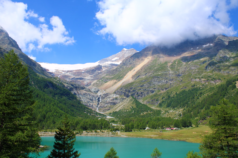
- Lago Branchino – This alpine lake, near Rifugio Alpe Corte. Dip your toes in the icy water or enjoy a picnic in the grass.
Plan Smartly
- Mind the altitude – Elevations on this trail range from 1,500 to over 2,800 meters.
Take breaks – Make use of the rifugi scattered along the trail. These mountain huts offer simple beds, hearty meals, and a chance to connect with other hikers. Booking ahead is a must in summer.
Right season – The trail is best from late June to early September, when snow has melted and skies are clearer.
Hike respectfully – Much of the route winds through protected landscapes. Stick to the path, please take your trash with you, and leave the beauty as you found it.
You Don’t Want to Miss
- The wild orchids and alpine flowers that bloom along high ridgelines in July.
Abandoned shepherd huts tucked away in quiet pastures—some now used as emergency bivouacs.
The sunrise from Passo del Vivione, a quiet crossing that offers views stretching all the way to Switzerland.
Trakking Monte Resegone: Lombardy, Italy
Ready to experience one of Italy’s most scenic mountain escapes? Monte Resegone, rising 1,875 meters (6,152 feet) above sea level, offers a breathtaking backdrop for your next outdoor adventure. Whether you’re a seasoned hiker, mountain biker, trail runner, or simply looking to immerse yourself in nature, the Monte Resegone area has something for you. This iconic mountain above Lecco is a true gem among mountain hikes near Milan.
Explore 7 hand-picked trails, ranging from moderate to challenging, each offering panoramic views, rugged landscapes, and unforgettable moments in the great outdoors.
Prefer a lighter journey with just as much natural charm? Head to Monte Barro—at 922 meters (3,025 feet), it offers a less strenuous yet still captivating hike.
Why Hike Monte Resegone?
Getting to the Bergamasque Alps is simple and budget-friendly. Bergamo Airport (BGY) is a popular hub served by many low-cost airlines, making it an accessible gateway to the region. From Bergamo, it’s just a short train ride to Lecco, located by the beautiful Lake Como. While Bergamo is a charming city worth a visit, it’s highly recommend setting aside time to explore the surrounding nature.
Top Trails Monte Resegone: Lombardy, Italy
1. Versasio – Rifugio Azzoni
Distance: 11.1 km
Difficulty: Challenging
Route Type: Point-to-point
Description: This trail starts near Lecco and leads to the Luigi Azzoni Refuge, situated just below the summit of Monte Resegone.
2. L’anello del Resegone via Piani d’Erna
Distance: 19.3 km
Difficulty: Challenging
Route Type: Loop
Description: This loop trail near Brumano is favored by mountain bikers and offers scenic vistas throughout its course.
3. Capanna Alpinisti – La Passata – Monte Resegone
Distance: 15.9 km
Difficulty: Challenging
Route Type: Loop
Description: Starting near Erve, this trail is suitable for backpacking, hiking, and mountain biking.
4. Morterone – Rifugio Azzoni
- Distance: Approximately 9 km
- Difficulty: Moderate
- Route Type: Out-and-back
Description: This trail begins in the village of Morterone and ascends to the Luigi Azzoni Refuge.
5. Piani d’Erna – Rifugio Azzoni via Lecco
- Distance: Approximately 5 km
- Difficulty: Moderate
- Route Type: Out-and-back
Description: Accessible via the Piani d’Erna cable car from Lecco, this trail provides a shorter route to the Luigi Azzoni Refuge.
6. Cima Fo – Ferrata del Centenario
- Distance: 10.1 km
- Difficulty: Challenging
- Route Type: Loop
Description: This trail near Lecco includes the historic Ferrata del Centenario, the oldest via ferrata in Lombardy and popular among hikers and rock climbers.
7. Capanna Alpinisti Monzesi – Piani d’Erna – Rifugio Stoppani
- Distance: Approximately 9 km
- Difficulty: Moderate
- Route Type: Out-and-back
- Description: This trail connects the Capanna Alpinisti Monzesi with Piani d’Erna and the Rifugio Stoppani.
Best Trails FAQs
What are some lesser-known hiking trails in Italy that offer breathtaking scenery but avoid the crowds?
Italy’s hidden hiking gems include Val di Mello in Lombardy, Sentiero degli Dei near Amalfi, and Monte Sibillini trails in Umbria and Marche. These routes combine stunning landscapes with fewer tourists compared to the Dolomites or Cinque Terre.
When is the best time of year to hike in Italy to avoid bad weather and peak tourist season?
The best months to hike in Italy are May–June and September–October, when the weather is mild and trails are less crowded. Summer brings heat and crowds, while winter limits access to mountain routes.
How difficult are Italy’s hiking trails and what gear do I need for moderate vs difficult hikes?
Italy’s trails range from easy coastal walks to challenging alpine ascents. Moderate hikes require sturdy shoes, water, and layers, while difficult routes demand trekking poles, proper boots, and sometimes crampons.
How do I prepare logistically for multi-day treks in Italy (accommodation, trail permits, food)?
Multi-day treks often use rifugi (mountain huts) that provide meals and beds, but advance booking is essential. Most trails don’t need permits, though you should plan food, water, and cash for remote areas.
Are there guided tours vs self-guided options, and what are the pros and cons for hiking in Italy’s hidden gems?
Guided tours provide safety, local knowledge, and logistics, but cost more. Self-guided hikes offer freedom and lower prices, ideal if you’re experienced and comfortable with maps or GPS.
Which Italian regions offer the best trails for coastal views vs mountain hiking?
For dramatic coastal hiking, head to Cinque Terre, Amalfi Coast, and Sardinia. For breathtaking mountain treks, explore the Dolomites, Gran Paradiso, and the Apennines.
What are some safety risks when hiking in remote trails in Italy (weather, wildlife, terrain) and how to mitigate them?
Rapid weather changes, steep terrain, and limited phone coverage are the main risks. Always check forecasts, carry maps or GPS, and pack essentials like layers, water, and a first-aid kit.
How accessible are Italy’s hiking trails using public transportation or from major airports and cities?
Many Italian trails are reachable by train and bus, especially near Cinque Terre, Lake Como, and the Dolomites. From airports like Milan or Rome, transfers to regional hubs make even remote trails accessible.
Can I hike in Italy’s remote areas year-round, and which trails remain open in off-season months?
High-altitude trails in the Alps close in winter due to snow, but coastal and lowland paths like Liguria, Tuscany, and Sicily remain open. Off-season hiking offers mild weather and fewer crowds.
What are the costs involved in hiking trips in Italy (trail fees, accommodation, guides), and how can one budget?
Most trails are free to access, but guided tours or park fees may apply. Budget €40–€80/day for food and lodging in rifugi, with higher costs for guided experiences.
Best Time to Go
The best season runs from late spring to early autumn. Clear skies and pleasant temperatures make this the perfect time for hiking. Winter adds a magical layer of snow, but it also increases difficulty—ideal only for experienced mountaineers.
Time to Hit the Trails!
So, grab your people, boot up and choose your experiences with adventure.